September 3, 2026
Stand at the edge of Manhattan and look down.
In many places, there isn’t much of an edge at all.
There is a railing.
Below the railing there may be concrete, steel, stone, a bulkhead and finally the water—the harbor kept at a respectable distance, as though New York were faintly suspicious of the very thing that made New York possible.
For a city composed of islands, we have developed an extraordinary talent for making the shoreline disappear.
It wasn’t always this way.
Before piers, seawalls, highways and bulkheads disciplined the waterfront into straight lines, the harbor’s margins were complicated places. There were marshes, tidal flats, beaches, rocky shallows and enormous oyster beds.
Then engineers arrived.
This is not necessarily an accusation.
Engineers gave the city docks, roads, sewers, tunnels, bridges and dry basements. New York needed a working waterfront, and working waterfronts require structures.
But somewhere in the long campaign to make the shoreline useful, we made much of it inaccessible—and ecologically rather dull.
Perhaps the next century of waterfront engineering should put some of the messiness back.
The Case for a Little Beach
Nobody is proposing turning Wall Street into Coney Island.
The more interesting possibility is much smaller.
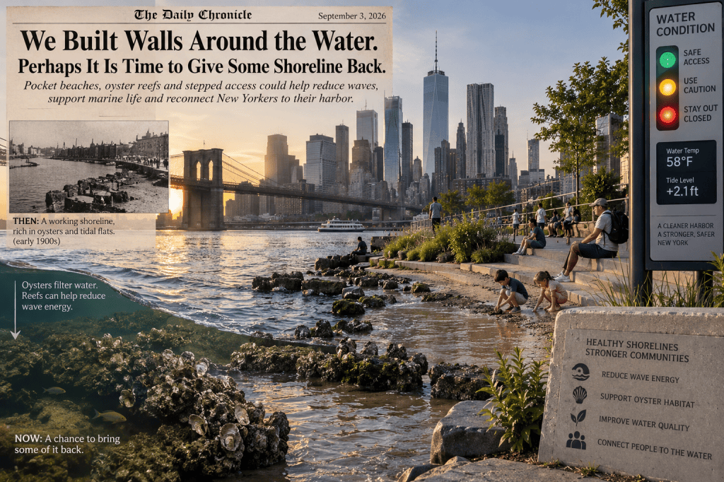
Imagine little shoreline enclaves tucked into appropriate stretches of the city’s waterfront: perhaps 100 feet here, 300 feet there.
Instead of a vertical wall meeting deep water, the land could descend gradually through terraces.
Concrete becomes stone.
Stone becomes gravel.
Gravel becomes sand or tidal substrate.
Marsh plants occupy protected corners.
Below the high-tide line, specially designed structures provide places for oysters and other marine organisms to establish themselves.
The result would not necessarily be a swimming beach.
It would be something New Yorkers have surprisingly little of:
A place where the city actually touches the harbor.
There is already a name for the broader engineering philosophy.
A living shoreline.
The idea is not to abandon conventional flood defenses. It is to supplement hard infrastructure, where conditions permit, with natural or nature-based elements.
NOAA describes living shorelines as combinations of vegetation, sand, rock, oyster reefs and other materials that can stabilize sheltered coasts while providing habitat.
In other words, instead of asking concrete to perform every job, give nature part of the shift.
Bring Back the Oyster
There may be no creature more thoroughly qualified for New York harbor duty than the oyster.
The harbor once possessed enormous oyster reefs.
Today restoration projects are trying to bring oyster habitat back.
An oyster reef is not simply a collection of future appetizers.
Oysters filter water. Their reefs provide habitat for fish, crabs and other organisms. And, in the right configuration, reefs can interfere with incoming waves before those waves reach the shoreline.
Research is beginning to put numbers behind that last point.
A recently studied constructed oyster reef in the Savannah River reduced wave energy by as much as 40 percent compared with sites without a reef.
That does not mean somebody can line Manhattan with oysters and cancel the flood-control budget.
Other research has found enormous differences in performance depending on reef elevation, inundation and design. A reef excellent for growing oysters may not necessarily be the reef configuration that blocks the most wave energy.
Nature, like City Hall, has zoning requirements.
But the principle is useful.
A shoreline can perform several jobs simultaneously.
It can be habitat.
It can be public space.
And it can be part of a larger system for absorbing waves and reducing erosion.
Don’t Ask an Oyster to Stop a Hurricane
There is a danger whenever an attractive environmental idea arrives in public policy.
Somebody inevitably asks it to perform miracles.
Living shorelines should not become an excuse to neglect serious flood protection.
Lower Manhattan faces a genuine coastal risk. New York is already spending billions on projects involving raised parkland, berms, floodwalls, gates and elevated waterfront infrastructure.
Those systems exist for a reason.
A pocket beach is not a floodwall.
A marsh is not a movable storm gate.
An oyster reef is not going to politely inform a major storm surge that Lower Manhattan is closed for the evening.
But flood resilience does not have to be one enormous wall.
Think in layers.
Offshore and intertidal habitat can weaken ordinary waves and reduce erosion.
A sloping shoreline can absorb energy differently from a vertical bulkhead.
Elevated parks and berms can provide another line of protection.
Floodwalls and gates can defend critical areas when the serious water arrives.
And drainage systems must deal with water that gets behind those defenses.
The oyster doesn’t replace the engineer.
The engineer gives the oyster a job.
Build Stairs Back to the Harbor
There is another reason to reconsider the vertical waterfront.
People should be able to approach the water.
Not everywhere.
Not recklessly.
But somewhere.
A carefully designed waterfront staircase could descend from promenade level toward a series of broad tidal terraces.
At ordinary water levels, the lower steps might bring visitors within a few feet of the harbor.
At high tide, some disappear beneath the water.
At exceptionally high water, the lower section closes.
The stairs themselves could become part park, part classroom and part tide gauge.
Put measurements on the side.
HIGH TIDE.
LOW TIDE.
SANDY, 2012.
PROJECTED 2050 FLOOD LEVEL.
Suddenly sea-level rise isn’t an abstract chart at a public meeting.
It is something a schoolchild can stand beside.
And perhaps understand.
Give the Water a Traffic Light
There is, however, one thing that should not be romanticized.
New York Harbor gets cold.
Very cold water can quickly become dangerous, particularly when people underestimate how rapidly hands and feet lose useful function.
If the city deliberately creates places where people can approach the water, it should also make the risk impossible to miss.
So borrow the most universally understood piece of street furniture New York has.
A traffic light.
At each designated water-access enclave, install a prominent WATER CONDITION signal.
GREEN — Normal public shoreline access. Lower terraces open.
YELLOW — Caution. Cold water, unusually high tide, strong current or deteriorating conditions. Stay out of the water.
RED — Lower shoreline closed. Dangerous water temperature, icing, flooding, storm conditions or other hazard.
The signal could be tied to instruments measuring water temperature and tide level, with weather and emergency conditions incorporated by the responsible agency.
And unlike a sign containing 11 paragraphs of municipal warnings, everybody understands red.
A visitor shouldn’t need a marine-science degree to know when January harbor water is a bad idea.
Red means don’t go down there.
And Don’t Call It a Swimming Beach
This distinction would be important.
Some of these spaces should exist simply to let people meet the shoreline.
Sit on a dry upper step.
Watch the tide.
Look for crabs.
See oysters growing.
Launch an approved kayak where conditions permit.
Attend a school ecology lesson.
Dip a hand into the harbor from a safe platform.
Watch a sunset without three feet of steel railing making the water seem like an exhibit at the zoo.
Swimming could remain prohibited unless a particular location meets the necessary water-quality, current, lifeguarding and safety standards.
Access does not have to mean permission to do everything.
Central Park allows you to approach a tree without authorizing you to climb to the top of it.
A Hundred Small Shorelines
The most appealing part of this idea is that it needn’t require rebuilding the entire harbor at once.
Start with a handful of experiments.
Find stretches of protected waterfront where wave conditions, navigation requirements, ecology and public access make sense.
Build one small tidal beach.
One oyster terrace.
One stepped shoreline.
One marsh pocket.
Instrument them heavily.
Measure erosion.
Measure wave energy.
Measure oyster survival.
Measure water quality.
Watch what happens during storms.
Watch what breaks during winter.
Ask whether people actually use the place.
Then improve the next one.
A city with hundreds of miles of shoreline can afford to experiment with a few hundred feet at a time.
The Straight Line Was Never Natural
New York has spent generations drawing hard lines between land and water.
Perhaps that made sense when the waterfront was primarily a machine for moving cargo.
But the harbor is changing again.
Old industrial waterfronts have become parks and neighborhoods. People who once went to the river to unload ships now go there to walk dogs, push strollers, run five miles and complain about apartment prices.
Our shoreline should change with them.
Not every seawall should disappear.
Some absolutely shouldn’t.
But neither should every encounter between New Yorker and harbor end at a railing.
Give us a few little beaches.
Give the oysters somewhere to build.
Give marsh grass somewhere to bend.
Give engineers permission to design shorelines that aren’t perfectly straight.
Build stairs down toward the tide—and put a red light at the top when January reminds everybody who’s boss.
For several centuries, New York has been asking how effectively it can keep the water out.
The next question may be more interesting.
Where can we safely let the shoreline back in?
 The ChillX Zone
Leave a comment